Index of All Cemeteries Alphabetical Index of All Burials Previous Page
Use the following to search across all the cemeteries listed.
Example: "Smith, Roger" (yes, use the quotes)
450 COUNTY HOME CEMETERY (2)
Location - County Home Road (SR 1346), Dobson, Surry Co., NC.
Coordinates: 36d 25m 17.6s N; 80d 42m 54.5s W Click here for Online Maps
Directions: From the intersection of North Main and West Kapp Streets (Old Courthouse Square) in Dobson, go north on N. Main Street (Old US Hwy 601 Business) for .9 mile and turn left onto Prison Camp Road. Follow Prison Camp Road (SR 1345) .9 mile and turn left onto County Home Road which leads into Fisher River Park. Go .2 mile and park in the Surry County Animal Shelter parking lot. From the rear of the Animal Shelter walk into an opening in the woods and follow the path uphill (northerly direction) for about 140 yards. Cemetery will be at end of path.
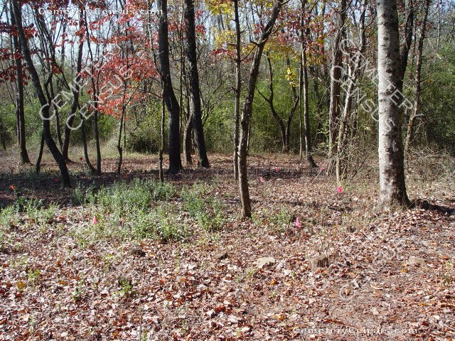
Before cleanup was started - View #1 - View #2. Current state of cleanup and grave identification - View #3 - View #4 - View #5.
The County Home (Poor House) of Surry County, now Hope Valley, became a haven for the unfortunate, disabled and unwanted in the county and operated from the 1880's to the 1950's. during these years residents who died were buried in County Home Cemetery # 1 (Cemetery Census 315) and then in Cemetery # 2. Both cemeteries are now incorporated into Fisher River Park (Surry County Parks and Recreation). Daniel White, Parks Director, plans to improve/upgrade the cemeteries as a part of the park. Boy scouts cleared the cemetery. More information will be forthcoming.
Estimated to be 40 + graves in the cemetery.
Initially surveyed and photographed by Joe Hicks, Gary Snow and Jack Luffman on 25 October, 2012 with the assistance of Parks Director Daniel White and Parks employee Sean Cheek.
Township or District: Dobson.
Public or Private: Public Access.
GPS Accuracy (ft.): 11
Elevation above sea level (ft.): 1133
Status of cemetery: recently partially cleared by boy scouts.
Surry County Parcel Number: 4997-00-46-5429
Web page updated 15 April 2021
Index of All Cemeteries Alphabetical Index of All Burials Previous Page
|
|
 |
)
)
)
)
)